
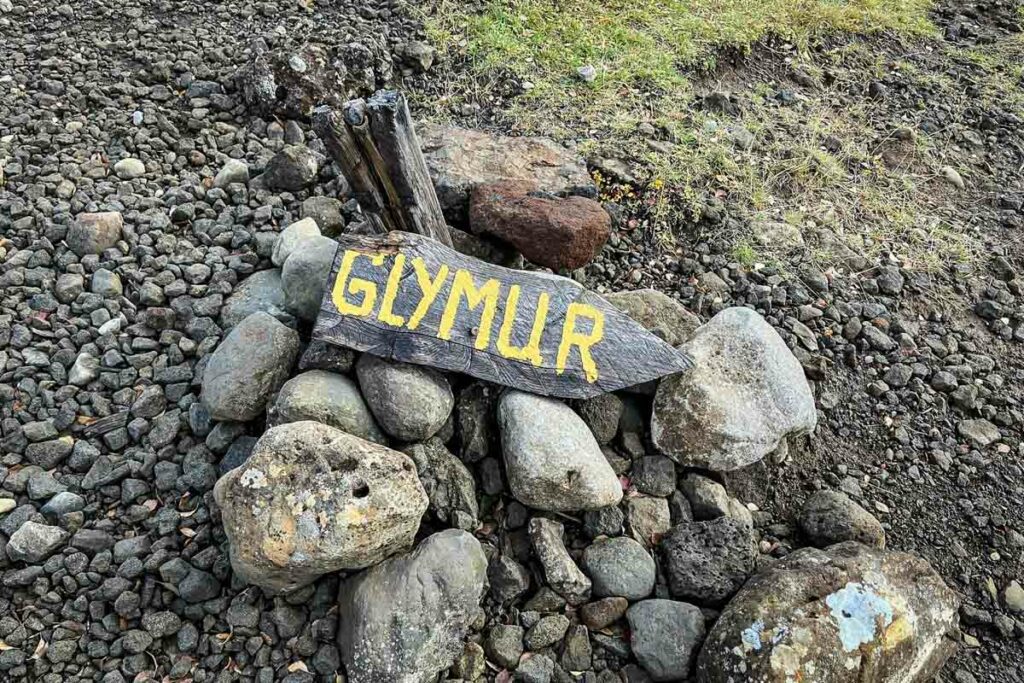
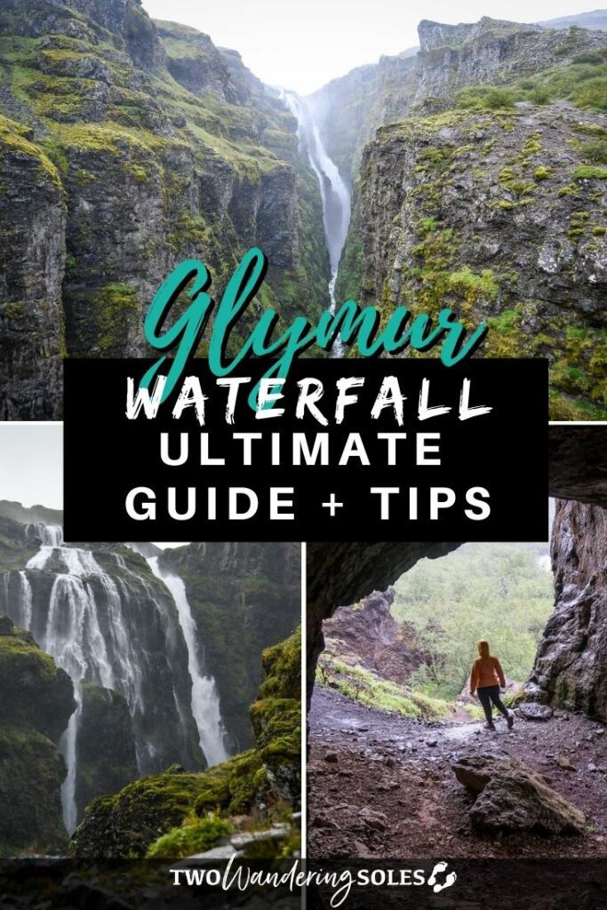
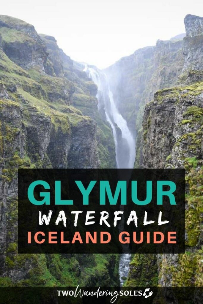
Iceland has thousands of waterfalls, yet few pack the punch of Glymur Waterfall, the country’s second-tallest. It requires a challenging hike to reach, but is well worth the effort. In this guide we’ll go over all the details to plan your hike to Glymur Waterfall.
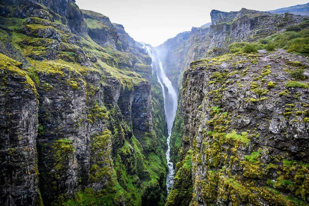
At nearly 200 meters (650 feet), Glymur is Iceland’s second-tallest waterfall—and reaching it is an adventure in itself. Tucked deep inside a lush canyon, the trail to Glymur involves river crossings, steep climbs, and some seriously heart-pumping moments, making it one of our favorite hikes in the country.
Just over an hour from Reykjavík, this hike is an easy day trip from the capital or a memorable stop on your Ring Road drive. And because Glymur takes real effort to reach, you’ll escape the crowds that flock to roadside waterfalls like Gullfoss and Skógafoss.
In this guide, we’ll walk you through exactly what to expect on the Glymur hike, what to pack, and the insider tips you’ll want to know before you go.
Glymur Waterfall Hiking Guide
- Hike at a glance
- Know before you go
- The route
- Tips for hiking to Glymur
- Where to stay nearby
- What to pack for hiking to Glymur
- Perfect Iceland itinerary
Glymur waterfall hike at a glance
- Exact location
- Parking & trailhead location
- Distance: 6.9 km (4.3-mile loop)
- Elevation gain: 429 m (1,407 ft)
- Difficulty rating: moderate
- Timing: 3-4 hours
- Alltrails notes
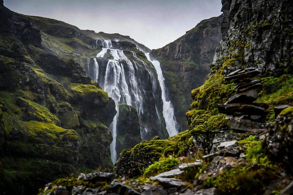
The Glymur waterfall hike packs a lot into one unforgettable trail: a deep river gorge, steep cliffside paths, a small cave, multiple river crossings, and sweeping valley views—all leading to Iceland’s second-tallest waterfall.
Unlike many other Iceland waterfalls, the journey here is just as memorable as the destination, with constant glimpses of Glymur and smaller cascades along the way.
Plan to spend at least 3 hours on the trail, expect to get your feet wet (waterproof hiking boots are a must!), and be sure to check weather conditions and download an offline map before setting out.
How tall is Glymur Waterfall?
Glymur Waterfall is 198 meters (650 feet) tall. It is the second tallest waterfall in Iceland.
Fun Fact: Until 2011, Glymur was thought to be the highest waterfall in Iceland. Researchers were finally able to measure a waterfall located near a glacier in the Highlands, which surpassed Glymur. This waterfall is known as Morsárfoss, and is very difficult to access. So chances are Glymur will be the tallest Icelandic waterfall you’ll see!
Our personal experience hiking to Glymur Waterfall
By the time we had gotten to Reykjavik at the end of our 2-week Ring Road road trip, we had seen a lot of waterfalls. Like, a lot, a lot.
But after overhearing another traveler say this hike was her very favorite experience in all of Iceland, the FOMO kicked in and I decided we just had to do it.
And I am so happy we did. It was one of my favorite hikes in Iceland!
The day we did this trek was raining pretty much the entire time. We made the most of it and put on all our waterproof layers and carried our camera in a dry bag (a must-pack item for Iceland, in our opinion!).
I will be honest and say that all the rain made the second river crossing a bit treacherous, and the path following it was becoming dangerous in some sections. We ended up turning around just shy of the end of the trial because it was too sketchy to continue.
If it is raining when you visit, use caution and only go as far as you see fit.
Funny story: After returning from the hike, our campervan battery wouldn’t start, so we had to hitchhike to a nearby farm where we borrowed jumper cables. It was quite the day!
Things to know before you go
Although it’s a relatively short hike, reaching Glymur waterfall involves river crossings and exposure to the elements. Make sure you know exactly what you’re getting into before setting out!
Best time of year for the Glymur waterfall hike
Summer is the best—and safest—time to hike to Glymur waterfall, typically from June through September. During this window, the log used for the first river crossing is usually in place, making it possible to reach the falls.
Avoid hiking after heavy rain, as water levels can rise quickly and make river crossings dangerous. Because parts of the trail involve slick rock, steep drop-offs, and exposed cliffs, this hike is not recommended if there’s snow or ice on the ground.
→ Related reading: Find out the best time to visit Iceland based on your travel style and itinerary.
How long does it take to hike to Glymur Waterfall?
Allow yourself between 3-4 hours for this trek, which factors in some time for photos and a snack at the waterfall.
If you hike the trail as a loop with only short intermittent breaks, it should take about 1.5 hours to reach the falls and another hour to hike back to your starting point.
Doing the trail as an out-and-back hike may shave off a few minutes, but overall, the two routes are very similar. The biggest difference is that the loop includes two river crossings, whereas the out-and-back requires just one.
How difficult is the Glymur Waterfall hike?
For anyone with previous hiking experience, this trail will provide some exciting, memorable adventure. It can be a little intimidating for first-timers, but still completely doable.
While not particularly long, the trail to Glymur Waterfall involves steep, tricky footing with some aggressive elevation gain, multiple river crossings, and sheer drop-offs.
All things considered, we rate this trail as moderate and can confidently say most hikers will agree. It’s not a long or very technical trek, but certainly presents a challenge in some sections.
The route
Below we breakdown the exact route for hiking to Glymur waterfall.
Getting started
Two main trails weave from the parking lot to Glymur Waterfall. They’re very similar in both distance and elevation gain, so it’s entirely up to you whether you do the out-and-back hike or the slightly more rugged loop.
Either way, be sure to download a GPS map before setting out or, at the very least, carry a map. There are a lot of criss-crossing paths, and the trail can be hard to follow in places, especially if it’s muddy.
For both options, head east from the car park towards the Botnsá River. Note that there’s actually another, easier trail to Glymur Falls heading north from the lot, but it skips over the gorge’s beautiful scenery.
Part 1: River crossing
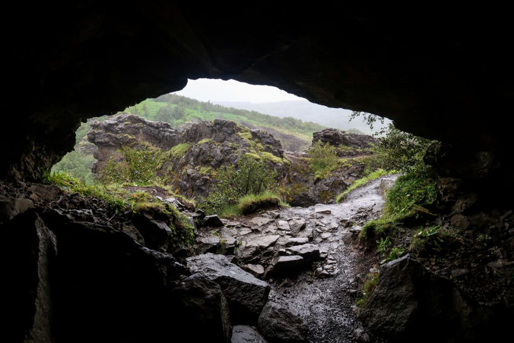
After 30 minutes of hiking on a nearly flat trail, you’ll reach a small cave. Veer left towards the riverbank and from here, you’ll continue upstream to the waterfall.
Soon, you’ll come across a large log with a wire handrail stretching across the river. Use this to make your first river crossing.
Important note: The log is taken down in winter months! While it’s difficult to find exact dates because it’s weather-dependent, historically, the log is up by early June and removed by early October.
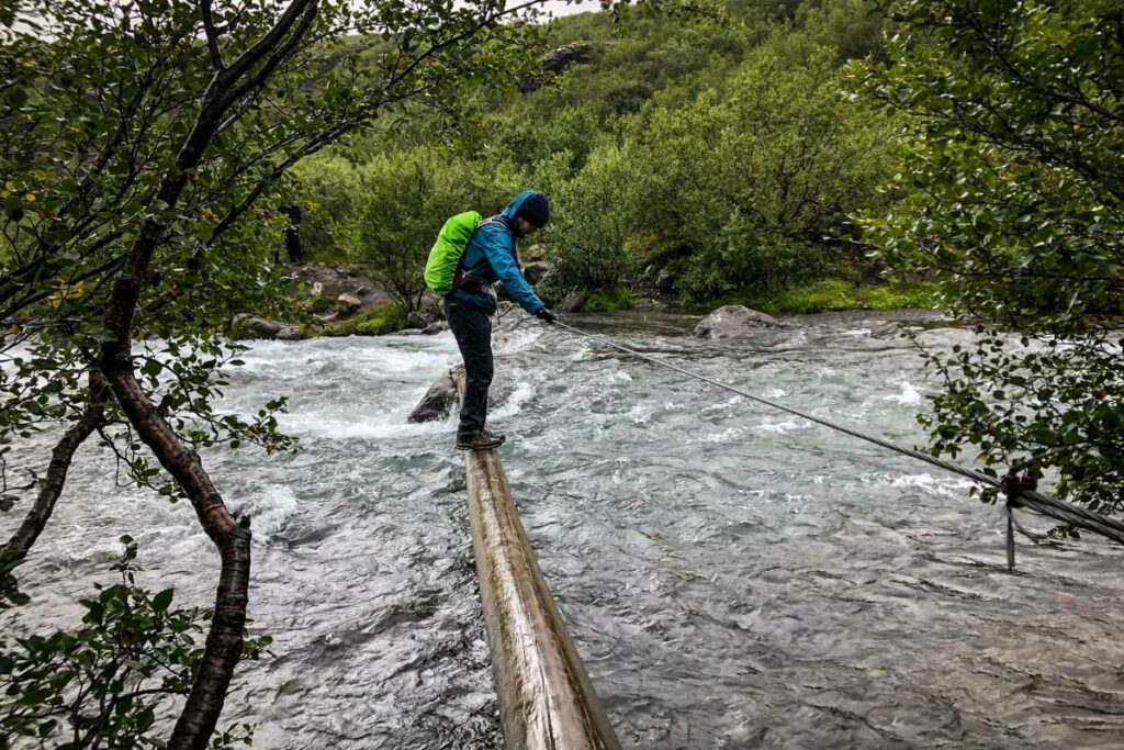
You can technically cross the river without the log, but it’s not recommended. During the months when the log isn’t in place, which happen to be the cold-weather months, the river moves incredibly fast. Do this at your own risk and exercise extreme caution.
Part 2: Steep ascent
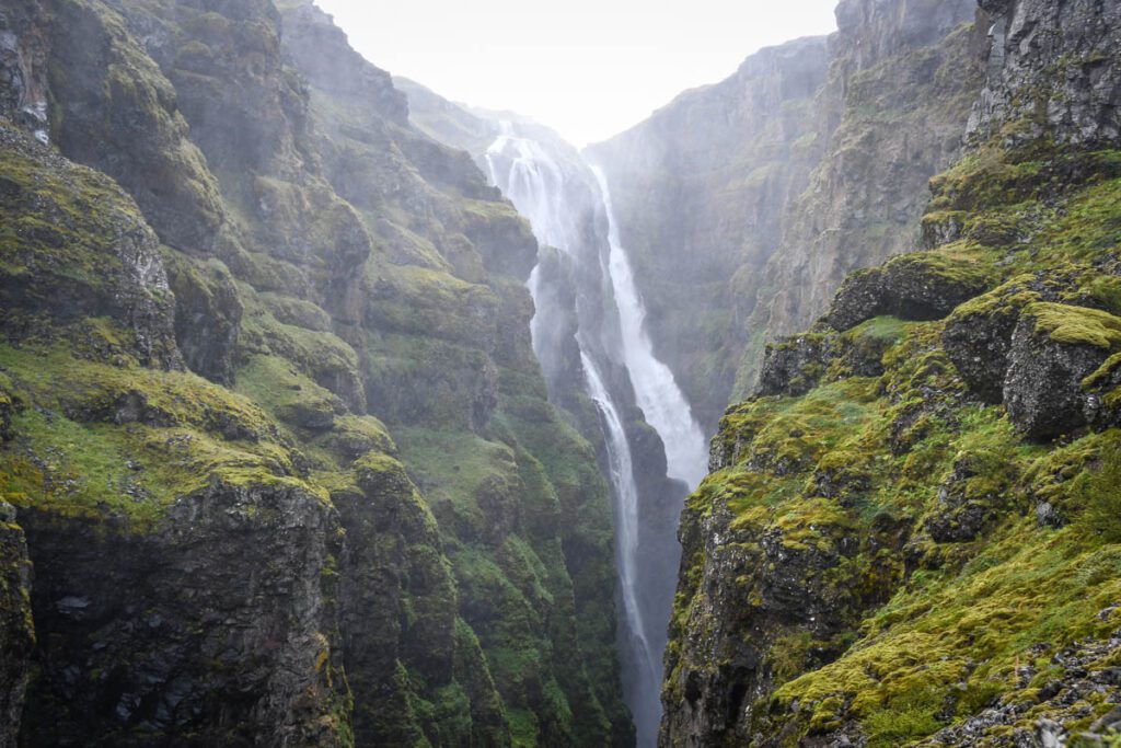
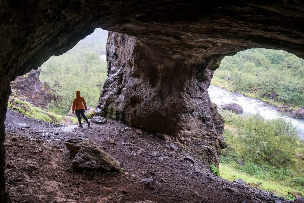
After gingerly crossing the log, continue heading upriver. Here, the trail gets noticeably more difficult, with steep ascents, uneven, rocky footing, and sheer drop-offs. This also means better views, however — the gorge opens to breathtaking vistas as you climb!
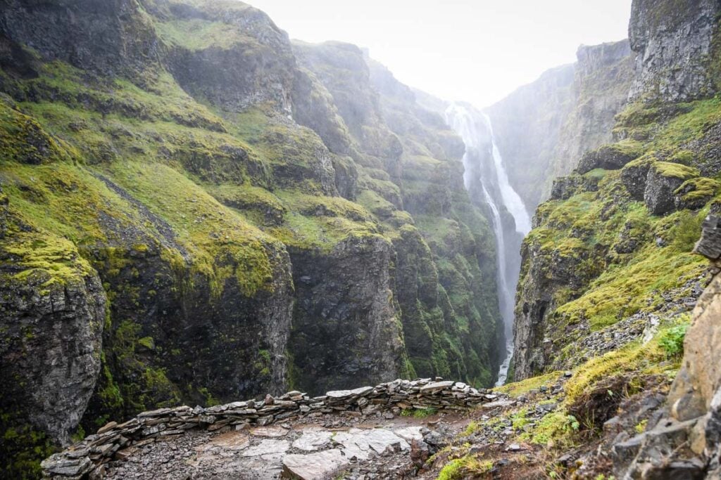
An hour and a half of hiking leads to the highest point on the trail, with stunning views of Glymur, the river, and further out toward the sea.
Part 3: Return or river crossing
At this point, you get to decide how you’ll get back to your vehicle. If you’re satisfied with the adventure or running low on time, or the weather is bad, the waterfall is a good place to turn around and head back the way you came.
If you’re up for more adventure and the weather is favorable, keep going past the waterfall to complete the hike as a loop. This involves a second, potentially more treacherous river crossing above the falls, so it’s not worth the risk in poor conditions!
Just above Glymur Waterfall, the river opens up and becomes wider and shallower, providing an area safe for crossing — in the right conditions. There’s no log or anything else to assist you, so the only way across is in.
Most people cross barefoot to avoid hiking the rest of the way with wet feet, but you can also bring a pair of water shoes.
Insider tip: Tuck a dry bag into your hiking pack to easily carry your wet shoes out.
Note that the water is freezing cold in any season!
Part 4: Complete the loop
To complete the loop back to your starting point, continue along the river. After a short distance, the trail splits slightly and, while it’s marked by rock cairns, it’s difficult to follow.
The trail that veers away from the riverbank is much more difficult, and the trail following it is easier. Specifically, the “other” trail involves a very steep descent and isn’t well-marked.
Whichever route you take, watch your footing, as the second half of the loop leaving Glymur Waterfall is similar to the ascent toward it, but even more rugged.
After about an hour, you’ll reach the cave you passed through at the beginning of the hike. Retrace your steps back to the car park along the same flat trail.
Psst! The Glymur hike is Day 13 in our Ring Road itinerary — right before an afternoon in the geothermal area and a golden hour soak at the Blue Lagoon as a final send-off. Our itinerary walks you through the whole day so you can plan your timing perfectly. See the full Ring Road Itinerary →
Tips for hiking to Glymur Waterfall
- Pack water shoes or hiking sandals for the second river crossing, as the smooth stones make it easy to slip
- Bring a rain jacket (a general tip for hiking in Iceland any time!) for the frequent sudden weather changes
- Download an offline trail map before setting out. We highly recommend Alltrails Pro!
- If it’s icy or weather conditions worsen, turn around
- This is an extremely popular hike, so start as early as possible to avoid crowds
- Stick to the river. The side trails leading away from it are where hikers get lost!
- Although Glymur Waterfall is close to Reyjavik, allot most of a full day
Where to stay near Glymur Waterfall
With the trailhead just over an hour from Reykjavik, Iceland’s capital is a convenient place to stay for visiting Glymur Waterfall. However, if you’d like to get out of the city, there are some closer accommodation options.
- Kidafell: This charming Icelandic cottage with beautiful fjord views rents single rooms or the entire house (up to 13 people). There’s wi-fi, a fireplace, library, and tire swing for a dose of childhood nostalgia, and in the summer, breakfast is included with stays.
- Hotel Glymur: Few things compare to the feeling of easing into a hot tub post-hike. At this hotel just 20 minutes from the trailhead, you’ll experience that, as well as an outrageously comfy bed, water or mountain views, and an onsite restaurant.
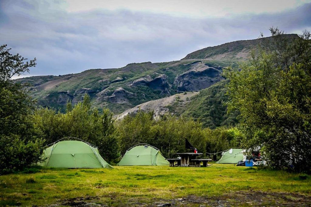
- Bjarteyjarsandur: This small campsite is only a 15-minute drive from the trailhead! Set on a family-run farm, you’ll enjoy panoramic bay views and be lulled to sleep by the gentle baas of sheep. There’s electricity, bathrooms with showers, and a restaurant serving home-cooked breakfast.
Psst! If this hike is on your Iceland list, our Ring Road itinerary has it mapped out alongside 13 other incredible days of adventures around the country. Get the Ring Road Itinerary!
What to pack for hiking to Glymur Waterfall
- Hiking daypack
- Don’t forget the rain cover!
- Dry bag (for valuables)
- Hydration pack and/or water bottles
- We take our insulated water bottles with us everywhere, but for hiking, we especially love the Grayl water purifying bottles
- Sun protection: sunscreen (even if its cloudy!), sunglasses, hat
- Warm layers (here is a great resource if you’re wondering what to wear hiking)
- Rain jacket
- Waterproof hiking boots
- Hiking poles (optional)
- Camera and tripod (this is our favorite for hiking)
- Plenty of snacks
- check out our favorite hiking snacks here!
- Navigation (downloaded or physical map)
- Insider tip: You’ll need Alltrails+ to download trail maps and see your real-time GPS location while hiking. Get your first week of Alltrails+ for FREE when you sign up using our link!)
- Battery pack (if you are relying on your phone)
Be sure to download our complete packing list for Iceland! It’s packed with good suggestions and insider tips to help plan your Italy trip. And it’s completely FREE, so why not!?

Want your entire trip planned for you? 👇🏼
We planned the perfect Ring Road Route with all the bucket list spots + hidden gems, and we’ve given you tips on pacing, where to stay, and worthwhile places to eat.

It will save you SO MUCH TIME & ensure you don’t miss out on the best places in the country! Learn more & see reviews here!
Don’t miss our other Iceland round ups…
Best Iceland hiking trails
We’ve done quite a bit of trekking around this jaw-dropping country and we’ve compiled a list of our favorite Iceland hikes to share with you. This article includes plenty of photos and details to help you plan your experience hiking in Iceland and know exactly what to expect.
Incredible Iceland waterfalls
Find out what to expect and exactly how to get to some of the best waterfalls in Iceland. This article breaks down all the details so you can easily visit them on your own trip. Plus we’re sharing a map with exact GPS locations and insider tips to help you plan your visit.
Incredible Iceland hot springs
If you’re a hot spring fanatic like us, this article breaks down all the details and where to find the best hot springs in Iceland. Plus we’re sharing some important tips for Icelandic hot springs etiquette so you don’t embarrass yourself or offend anyone (you’re welcome!).
Plan your trip to Iceland
We have TONS of resources on travel in Iceland and how to make the most out of your trip. Check out our Iceland Homepage for all the answers to your most burning questions, or read some of our favorite articles below.
- Check out all of our top recommendations for things to do in Iceland.
- Figure out thebest time to visit Iceland based on weather, crowds, and activities.
- Start with this 7-day Iceland itinerary if it’s your first time visiting.
- This step-by-step guide will help you plan an unforgettable Iceland road trip.
- You’ll want to keep this guide handy if you plan on driving Iceland’s Golden Circle.
- Bookmark these must-see stops along Iceland’s Ring Road before you hit the road.
- Read up on all the actually cool things to do in Reykjavik.
- Be sure to download these essential Iceland travel apps before your trip!
Want to upgrade your experience in Iceland?
We’ve created a fully interactive, custom map of Iceland that includes all of our personal recommendations, restaurants, hidden gems, viewpoints and unique stays.
Pair that with our done-for-you Iceland Ring Road Itinerary—so you can spend less time researching and more time soaking in Iceland’s epic landscapes.

This 14–day itinerary takes you along Iceland’s entire Ring Road, blending adventure with a touch of luxury. You’ll visit iconic sights like Skogafoss and Diamond Beach, plus off-the-beaten-path spots most tourists miss (like a hidden cave you can dine in by candle light!).
With detailed daily plans, insider tips, driving directions, and hand-picked stays, this guide takes the guesswork out of planning so you can experience Iceland stress-free.
Don’t miss your chance to grab our Iceland packing list!

Click the banner to download our complete packing list for Iceland! It’s packed with good suggestions and insider tips to help plan your Iceland trip.
And it’s completely FREE, so why not!?
Save this article on Pinterest for later!
We want to hear from you!
Are you planning to visit Glymur waterfall on your trip to Iceland and still have questions? Leave your comment below and we’ll do our best to get back to you!

Katie Diederichs is the lead writer and co-founder of Two Wandering Soles, where she creates in-depth travel guides, itineraries, and tips designed to help readers plan better trips with confidence. With a background in journalism, photography, and design, she combines thorough research with firsthand experience to deliver clear, practical, and visually driven travel content. As the primary trip planner, Katie turns complex logistics into easy-to-follow advice travelers can actually use.